Water
Taking Notice to Take Action: Integrating Environment, Community, and Health A Health in the Watershed Atlas of the Battle River and Sounding Creek Watersheds
Introduction
The following is a summary of water considerations from the latest state of the watershed report to inform action for a healthy economy, environment and communities in the Battle River and Sounding Creek Watersheds.
A watershed is a drainage basin or area of land that catches rain and snow and drains it into a common body of water. A healthy sustainable watershed is a place where community well-being is supported by a strong economy and a healthy environment.
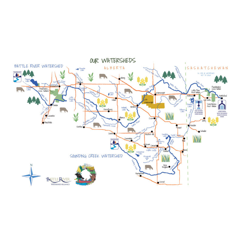
The Battle River Watershed covers 30,000 square kilometres across east-central Alberta and drains into the Battle River. The Sounding Creek Watershed covers 10,000 square kilometres. The creek flows into Sounding Lake; from there, water flows through Eyehill Creek to Manitou Lake in Saskatchewan.

 Water Quantity
These watersheds are uniquely prairie-fed. Far removed from the mountains, nature provides water through precipitation, groundwater, and water stored in wetlands, lakes, and natural reservoirs (without the added benefit of runoff from mountain snowpack). To manage low flow periods and vulnerability to floods and drought, communities must manage and balance water demand and availability.
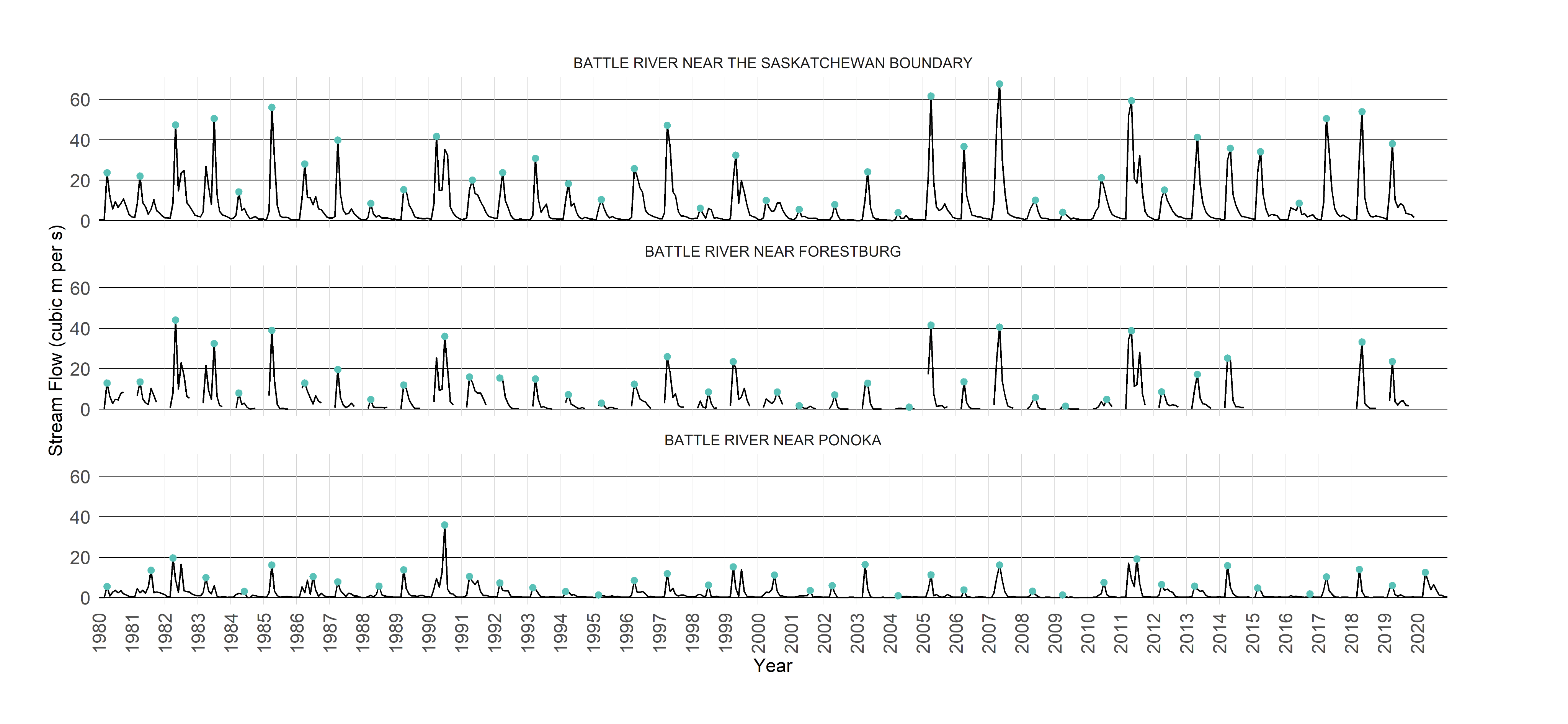
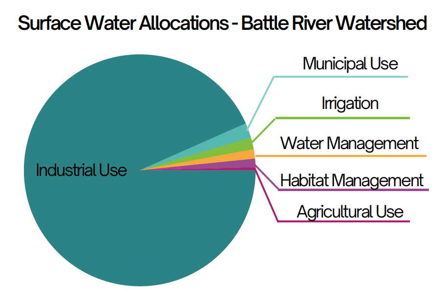
Battle River flows are regularly gauged during the ice-free portion of the year. Since records began in the early 1900s, water availability has varied greatly from year to year. Very high flows and flooding occurred in 1974, and the lowest flow year was recorded in 1930. Low flows and drought conditions are common, and their frequency and intensity are expected to increase due to changing weather and climate patterns. Water flow is crucial for the health of aquatic ecosystems and licenced water uses in the basin. Around 20% of the Battle River annual flow is allocated for consumptive use. Industry, agriculture, and communities are primary water users.
Did you know?
Drinking water in these watersheds comes from three sources – approximately one third of the population relies on surface water sources, a third on regional waterlines that bring water from the North Saskatchewan and Red Deer rivers, and a third on groundwater wells.
Contributing Areas
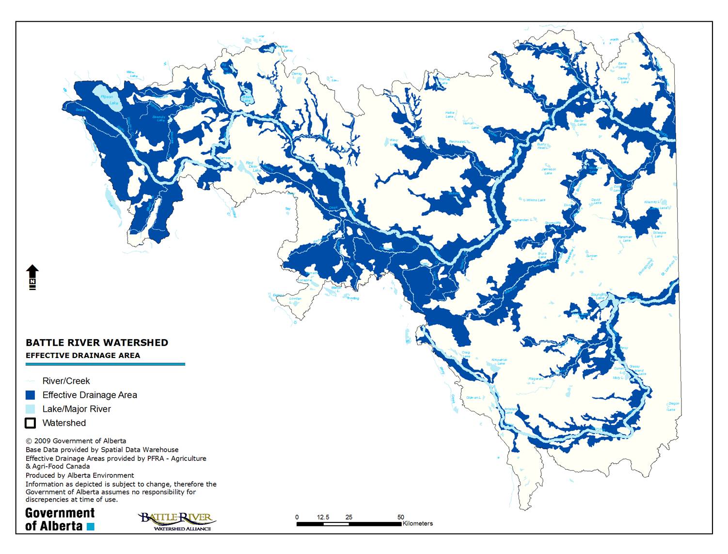
Landscapes that regularly contribute runoff to local water bodies (also known as Effective Drainage Areas) are crucial to water supplies and availability. Development that alters runoff patterns, disrupts stream flows, or impacts water quality may not be appropriate in these areas. In noncontributing areas, water security is strengthened through water storage in small lakes and wetlands, supporting soil moisture and groundwater recharge.
Water Security

Community actions to support resilience in prairie-fed watersheds include:
- Water conservation,
- Efficient water use and reuse,
- Water sharing agreements,
- Alternative water sources and off-stream storage,
- Wetland retention
Protecting natural landscapes is also critical for water storage and purification, flood and drought mitigation, groundwater recharge, biodiversity, and other vital ecosystem functions. This includes native grasslands, tame pasture, wetlands, riparian areas, trees and forests.

Did you know?
Approximately two-thirds of historic wetlands have been lost due to human activities, and native grasslands cover around 10% of these watersheds. Conservation and restoration of natural assets is a key pillar of watershed management and community action.
 Water Quality
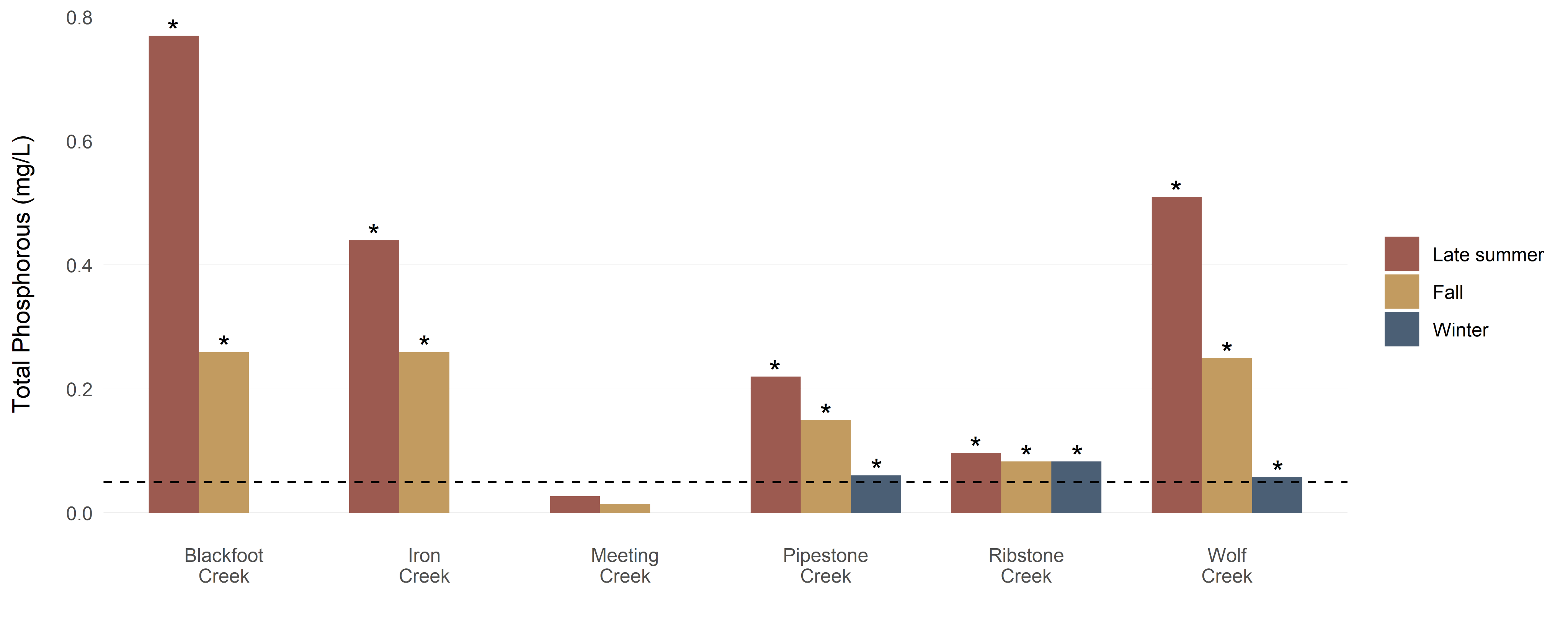
Two provincial monitoring stations track water quality in the western portion of the Battle River. Surveys of eastern parts of the river, tributaries, and waterbodies are monitored less frequently. Sounding Creek is not monitored.
The Alberta River Water Quality Index (2003-2016) provided data on metals, nutrients, bacteria, and pesticides. Nutrients are a key concern, with scores often exceeding guidelines.
Monitoring in tributary streams shows water quality exceeding guidelines for healthy aquatic ecosystems (shown here as values above the dashed line), particularly for dissolved oxygen and nutrients like phosphorus and nitrogen.
 Water-Related Advisories
Water advisories including cyanobacteria blooms, fecal coliforms, and boil water warnings are present within these watersheds. The SOW reports on Federal and Provincial boil advisories on public systems. These datasets do not report on advisories for private systems. Most lakes in these watersheds are eutrophic i.e. having high nutrient levels causing cyanobacteria or algal blooms. Monitoring for cyanobacteria is limited to recreational beaches.
Indigenous Communities Impacted by Advisories
There are many boil-water advisories on private well systems in the Maskwacis Cree Nations, including residents at Pigeon Lake, which are managed by the Nations. In general, boil water advisories are 2.5 times more frequent for First Nations community systems and 30 percent of First Nations communities in Canada are classified as high risk systems.
Lake and river water quality advisories impact traditional harvesting areas as algal blooms impact fish health and recreation.
What does all this mean?
How can we move forward with this information to make real and meaningful change?
Call to Action
- Celebrate and encourage local stewardship
- Implement personal water conservation practices such as low flow fixtures
- Avoid swimming when algal blooms are visible and do not allow pets to swim
- Reduce the use of pollutants such as fertilizer that impact local water bodies
- Implement beneficial crop and grazing management practices, such as encouraging water retention and limiting drainage
- Protect, restore, and maintain wetlands, riparian areas (shoreline vegetation), and healthy tree stands

Connect the dots
How does this affect the rest of watershed health?


- Water quality and quantity affect aquatic ecosystems, fish health, and local land use, especially in wetlands and riparian areas.
- Healthy aquatic and riparian ecosystems provide valuable services for communities, influencing recreation and public health.
Acknowledging Lands and People
The Battle River and Sounding Creek watersheds have been the home, meeting ground and travelling route for many Indigenous Peoples since time immemorial. We gratefully acknowledge the ancestral territory and ongoing presence of Indigenous Peoples and Nations within these watersheds. Their experiences, teachings, knowledge and wisdom inform and enrich our collective efforts to care for the land and water of this region. These watersheds are located in Treaty 6 and 7 territory and the Métis homeland. Fulfilling the spirit and intent of the treaties is an ongoing process, and the Battle River Watershed Alliance is committed to building strong and respectful relationships with the Indigenous Peoples of this land, with all living beings, and with the land and water on which we all depend.