The Battle River Watershed Alliance and North Saskatchewan Watershed Alliance have collaborated to complete riparian intactness assessments for the North Saskatchewan and Battle River watersheds using remote sensing (satellite) data. The first stage of this work was to develop a high-resolution land cover dataset. We then used this dataset to rate the “intactness” of riparian areas across our watersheds, which gives us an idea of how healthy or unhealthy these areas are. This information will help the BRWA, NSWA, municipalities, agricultural producers, and other land managers identify priority areas for riparian conservation and restoration projects.
You can view the riparian intactness data online through the Riparian Web Portal, which also showcases examples of on-the-ground stewardship projects and houses a wealth of resources to support you in caring for riparian areas in your local watershed.
Visit the Riparian Web Portal at riparian.info to explore the data!
You can also view the final report and other resources by clicking here.
If you are a planner or project manager involved in agriculture, ENGOs, or any level of government, we are offering workshops to teach you more about this project and how to use the Riparian Web Portal to inform your work and share your stewardship projects.
Visit our EventBrite page to learn more about these workshops (click on “Past Events”).
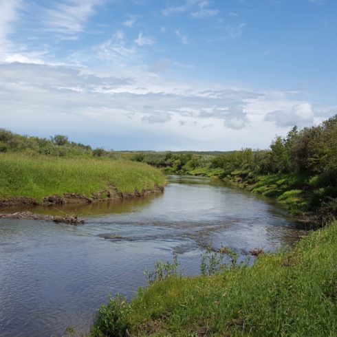
Riparian areas are the land adjacent to a water body where the plants and soils are strongly influenced by water. Healthy riparian areas play a critical role in purifying our water through filtering and reducing surface water runoff from surrounding uplands and trapping sediment and associated pollutants such as nutrients, pesticides and bacteria.
The vegetation slows the water in streams and rivers to reduce erosion, helps keep waters cool, and provides fish food and habitat. Riparian areas also contribute to water storage, which helps mediate the effects of both floods and drought.
Healthy riparian areas support local biodiversity by providing cover, food, and access to water, as well as creating natural corridors. Humans enjoy and use riparian areas for these reasons too. As a result, human activity can impact the health of riparian areas.
The BRWA has developed recommendations for riparian area management in the Battle River and Sounding Creek watersheds of Alberta, and several projects are complete or currently underway.
Starting in 2012, the BRWA has supported four Riparian Restoration Programs, including; the Ferry Point region of Camrose County (2014), Ponoka County (2017), Iron Creek (2017), and the Buffalo Trail region around Hwy 41 (2018).
These programs provide landowners logistical and financial support for projects that help improve the health of the Battle River and its tributaries, as well as lakes and wetlands. Projects can include riparian health surveys, livestock water systems, fencing, tree plantings, and other ideas from landowners.
These projects are part of our implementation phase of the Riparian Areas component of the Watershed Management Plan.
Riparian Areas Background Research Report, PDF
Riparian Areas Policy Advice, PDF
Riparian Areas Implementation Guidelines, PDF